SWITZERLAND
STRADA ALTA
|
ALL ABOUT SWITZERLAND |
|
HIKING LEVENTINA STRADA ALTA |
|||||
|
Hiking Central Switzerland · Maderanertal · Glattalp Eastern Switzerland · Pizol - 5 Lakes Southern Switzerland · Strada Alta |
|
| Starting point: | Airolo |
| > go by train: timetables |
From northern Switzerland: hourly Interregio trains alternately from Basel-Lucerne or Schaffhausen-Zurich with connection from the other point of origin at Arth-Goldau junction From southern Switzerland: hourly Interregio trains from Locarno - Bellinzona with connection from Chiasso - Lugano at Bellinzona Please note that Intercity/Eurocity trains to Bellinzona-Lugano-Chiasso(-Milano) do stop at Arth-Goldau to make the connection, but will not stop in Airolo |
| Classification: | Elevated trail with scenic view over Leventina valley |
| Degree of difficulty: | Easy to go (yellow signs) |
| Duration: | 1 to 3 days, depending on start and destination point and individual pace, well trained people easily march the whole route in two days. Swiss people often do the upper part as a one-day excursion on a Sunday with rain in northern Switzerland but sunshine in Ticino |
| Season: | Almost all year, except shortly after heavy snowfall |
| Route and intermediate stops: |
1st day: 5 ½ hours, uphill 580 m [1900 ft], downhill 570 m [1866 ft],
17 km [10.6 mi] Airolo 1141 m [3736 ft] above sea level - Valle 1175 m [3847 ft] (15 min, paved) Valle - Madrano 1156 m [3785 ft] (15 min, unpaved by-road crossing Canaria brook) Madrano - Brugnasco 1385 m [4535 ft] (45 min, 2/3 hiking path, 1/3 paved by-road) Brugnasco - Altanca 1390 m [4551 ft] (50 min, paved by-road) Altanca - Ronco 1368 m [4479 ft] (20 min, paved by-road) Ronco - Deggio 1208 m [3945 ft] (30 min, 3/4 hiking path, 1/4 paved by-road) Deggio - Lurengo 1324 m [4335 ft] (50 min, hiking path) Lurengo - Bosco d'Öss 1346 m (20 min, hiking path) Bosco d'Öss - Freggio 1037 m (50 min, hiking path, 1/2 km [1/3 mi] steep downhill) Freggio - Osco 1157 m [3788 ft] (40 min, hiking path) Almost half of this route (7.5 km/4.7 mi) consists of paved by-roads, which is not necessarily what you would be looking for on an alpine hike. The rest is small hiking paths leading through meadows and forests. In winter, the by-roads may be an advantage, however, and you can do the whole section from Airolo to Lurengo on by-roads, if you like. There is a postbus from Lurengo down to the valley. You may also take a postbus to Deggio or Osco and start a two days tour there, avoiding the paved sections. 2nd day: 3 ¾ hours, uphill 440 m [1440 ft], downhill 620 m [2030 ft], 12 km [7.5 mi] Osco 1157 m [3788 ft] - Calpiogna 1143 m [3743 ft] (40 min, hiking path) Calpiogna - Figgione 1040 m [3405 ft] (30 min, hiking path) Figgione - Rossura 1060 m [3471 ft] (10 min, hiking path) Rossura - Tengia 1103 m [3612 ft] (25 min, hiking path) Tengia - Calonico 970 m [3176 ft] (50 min, hiking path) Calonico - Grotto Pro Bell 898 m [2940 ft] (15 min, hiking path) Pro Bell - Anzonico 979 m [3206 ft] (50 min, hiking path) On this section, paved by-roads may be avoided almost completely. 3rd day: 4 ½ hours, uphill 335 m [1100 ft], downhill 980 m [3210 ft], 12 km [7.5 mi] Anzonico 979 m [3206 ft] - Segno 1090 m [3569], (40 min, hiking path) Segno - Cavagnago 1020 m [3340 ft] (10 min, hiking path) Cavagnago - Ronzano 1105 m [3618 ft] (50 min, hiking path) Ronzano - Sobrio 1130 m [3700 ft] (10 min, hiking path) Sobrio - Valecc 1144 m [3746 ft] (10 min, hiking path) Valecc - Vallone gorges - Bidrè di sopra - Bidrè 1032 m [3379 ft] (25 min, hiking path) Bidrè - Diganengo 964 m [3157 ft] (40 min, hiking path) Diganengo - Corecco 794 m [2600 ft] (25 min) Corecco - Pollegio 296 m [969 ft] (1 h) On this section, paved by-roads may be avoided almost completely. |
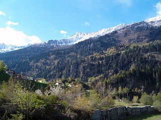
| Pictures | ||||
|---|---|---|---|---|
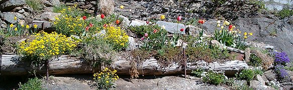 Alpine flower garden |
||||
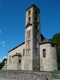 church |
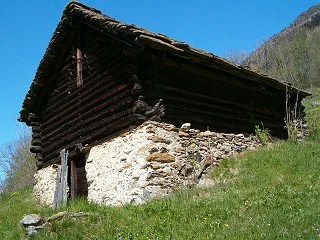 old alpine cottage |
|||

Short quotations allowed but with precise declaration of origin (Link).
Reproduction of substantial parts and pictures in printed or electronic form
only with explicit written consent by the editor.
| Disclaimer | Privacy Policy | www.all-about-switzerland.info © 2005-2010 All Rights Reserved | Editor | ||